Notes on Lawers
The earliest documentary evidence of the
McDougalls comes from a record in the Kenmore Old Parish Register showing Hugh
McDougall’s marriage to Mary Ferguson in 1775 at Borland Farm in Fernan, near
Fortingall. Around 1812, the family moved
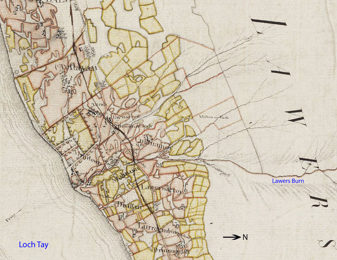
west along the loch to Lawers and took up a tenancy in the township of Cuiltrannich.
Cuiltrannich, meaning nook of bracken in Gaelic, was part of the Breadalbane lands.
In 1770 it was registered to Colonel Robertson of Lawers, for an annual rental of £305.
The exact extents of
Cuiltrannich are
unknown, but the cultivated area appears to have covered at least 45 acres of
ground on the lower slopes of Ben Lawers, just west of the Lawers Burn ravine.
The surveyors working for the Farquarson Survey of 1769 observed that, "…the bank on both sides of the [Lawers]
burn is so steep and dangerous especially near the head of the farms as frequently to
occasion the death of some of their cattle. On this account both sides of the burn, where
danger is, ought to be enclosed and planted with firs or oaks." *
At the time of the Survey, there were 3 smallholdings. 2 more were constructed later,
further up the hill, and may have been allocated to the soldiers known as the Breadalbane Fencibles who returned from duty in Europe in 1797.
One of the lower farmhouses remained unchanged, and was occupied, well into the 20th century **. Its ruins, and some others, are still visible,
along with a prominent, sunken access track.
The township had a smithy, a school, a lime kiln and a meal mill. It also possessed the only lint mill on the north side of Loch Tay.
This was located beside the Lawers Burn below the Killin to Kenmore road, close to the loch. It was used to process flax into linen.
*
Plans and Book of reference relating to survey of the north side of Lochtay by John Farquharson, 1769
** Rural settlement in the Scottish Highlands, 1750-1850:
A comparative study of Lochtayside and Assynt - Vols 1, 2, 3 by
Alexander Morrison, 1985
On the east side of the ravine is an ancient stone circle, Machuim. First described in Thomas Pennant's A Tour in Scotland (1772), the local
writer William A. Gillies’s In Famed Breadalbane (1938) said that "a recent examination of
the ground around the circle...suggests that at one time there was an outer
circle of stones concentric with the existing one. Most of the stones were removed in order to
make more of the field available for cultivation, but there are still large
stones buried within a few inches of the surface." J. McDiarmid wrote
in 1910 in his Folklore of Breadalbane
of a man from the nearby
The
Lady of Lawers
Lawers was sited at the mouth of its
eponymous Burn. The castle of the lairds
of Lawers was probably built close to the water's edge on the west bank. It was
destroyed in 1645 and replaced by a less pretentious building that was occupied
by the tenants of the farm of Milton of Lawers down to the latter part of last
century. The two storied house, the
ruins of which are still visible, was reputed to be Tigh
Ban-tigheaona Larbhuir, the
House of the Lady of Lawers, who was said to have been a Stewart of Appin, and the wife of one of the lairds of Lawers. The Lady was evidently a woman gifted with a
wonderful measure of wisdom and shrewdness. Among the predictions attributed to her is one
connected with the building of the church, which was probably built by Sir
James Campbell, the sixth laird. When the church was
nearing completion, she said that the ridging-stones would never be placed on
the roof. The builders brought stones
for the ridge from
Several of the Lady's sayings predicted
changes in the social and economic conditions of the district. A prophecy about fire-coaches yet to be seen
crossing Druimuachder Pass was accepted as
foretelling the coming of the Highland Railway over Drumochter.
She foresaw a period when the population would greatly increase and the land be intensively cultivated: “there will be a mill on every stream
and a plough in every field, and the two sides of Loch Tay will become a kail garden”. This prophecy
would appear to have come true by the end of the 18th Century, when
there were fourteen mills along the lochside; on the
south side alone there were nearly two hundred ploughs between Auchmore and Taymouth.
On
living standards in Breadalbane
The reasons for this abundance are not
immediately obvious, since the land could barely support its residents. Historically, cultivation was on the runrig system, under the old in-field and out-field arrangement. On the poor upland soils, this antiquated
arrangement gave the Highlanders a marginal existence. The minister of Fortingal parish* found it
hard to believe that they could exist on so little: “They bled their cows several times in the
year, boiled the blood, eat a little of it like bread,
and a most lasting meal it was.” The
Earls of Breadalbane tried to relieve the pressure on the over-burdened land by
building roads and bridges to open up the country and facilitate transport. They
were instrumental in establishing flax processing as a major industry on Loch
Tayside. They sent some farmers’ sons to
This was not exactly the experience of Robert
Heron writing of his 1793 Observations
Made in a Journey through the Western Counties of Scotland. On the banks of the River Tummel,
he found refreshment in a house that “exhibited a scene of nastiness and
simplicity which convinced me that the primitive manners of my country were not
everywhere lost”. There were also mixed
opinions among the clerical authors of the Statistical Reports* concerning the
standards of living of their parishioners - some despaired of their poverty,
while others thought they were doing rather well. The minister of
By contrast, in neighbouring Rannoch, the
old ‘Stake and Rise’ houses (one had to enter on all fours and, once inside,
would be unable to stand upright) had been replaced by “comfortable houses
built of stone”. “People”, stated the
minister of Fortingal*, writing about the 1750s, “were starving.” Yet, 50 years
later, although rents had tripled, “the people have fulness
of bread”. In Killin, there was some
depopulation, “by the union of farms and the number of sheep introduced …. and it must be admitted that, owing to these causes, the
number of people has decreased considerably in the higher parts … but it has
increased in the lower parts … particularly in the
So the apparent discrepancies in the
ministerial accounts* of the day were simply matters of emphasis. For example, depopulation, when “swarms leave
the country every year”, was certainly taking place, but it was chiefly in the
remote hill areas. One of the reasons
was the increased stocking of farms with sheep, which required only a few
shepherds to manage. Pushed off their farms,
the landless refugees ended up in the villages and found work in service, as workers
in the flax industry or as masons, joiners, shoemakers, smiths, farriers and other
craftsmen. And some, of course, emigrated to the new lands overseas.
The
Cheviot comes to Loch Tay
The Lady of Lawers also foretold that the
jaws of the sheep would drive the plough out of the ground, that many holdings
would become one holding and that the homesteads on Loch Tayside would be so
far apart that a cock would not be able to hear his neighbour crow. This
prophecy predicted the evictions that took place on Loch Tayside during the 1830s,
when people were cleared from the land in order to establish large sheep runs. As
John Campbell of Lochend wrote, "the sides of
Loch Tay in general were never intended by nature for the plough, and if the
fertile, level lands in the better climate of England were thought to be more
profitable under grass than under the plough, what could be expected from
cultivation of the steep, broken patches of land on Lochtayside,
however good the quality might be, so far north, so high above the sea and so
frequently deluged with rain?" There had been attempts to introduce the
Cheviot sheep to Breadalbane farms in the 18th Century but they were not well
received by the locals. However, in 1834, the Second Marquis allowed his
factor, James Wyllie, to evict families and to populate his farms with
Cheviots. By 1838, fourteen families had
been removed forcibly from Rhynachuilig, twelve from Edramchie, thirteen from Kiltyrie,
nine from Cloichran, and nineteen from the farm of Acharn, all on the lochside.
There is no mention of Lawers or
Cuiltrannich in this dismal roll call and, to judge from the numbers crammed
into the longhouses at the time of the 1841 Census, they escaped the terror. The evictions were carried out with ruthless
severity. No sooner were the people
turned out of their homes than the thatch was set on fire to prevent them from
returning. A man who was very active as
an agent in carrying out the dastardly work was himself evicted, and forced to
emigrate. As he was leaving the township
someone asked him: "Is there no more dirty work to be done in Breadalbane
when they are sending you away?" After
a decade, the land was striking in its emptiness. Of the 3500 inhabitants once
living on Loch Tayside, only one hundred were left by 1850. That year the Second Marquis tried to raise a Fencible Regiment, as his father had successfully done in
the 18th Century. He found no recruits. An old man of Loch Tayside is reputed to have growled
at him to "Put your red coats on the backs of the sheep that have replaced
the men!"
Although the evictions came to an end,
depopulation continued, and the land gradually went out of cultivation. The old
primitive houses built with dry-stone walls and thatched roofs decayed. Young people left to go to the cities, in the
case of the young Duncan McDougall, to
Some of her other prophecies refer to the
old
*Statistical
Accounts for